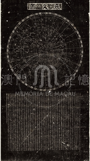
The stele Celestial Chart map ranks as China's national antique, boasting its significance in the world history of ancient science. In the era of Song Dynasty, the cartographer Huang Shang presented these eight maps to Zhao Kuo, the then prince Jiawang, with only the celestial maps and other geographic maps being engraved in steles by Wang Zhi Yuan and thus existing till now.
This celestial map adopted the Chinese ancient crafts, Gai tu (蓋圖) in the twelfth century. The depiction of more than 1,400 stars is aligned with the astronomical observation results in the early Northern Song Dynasty. Based on the profound details, it has been the most precise ancient star map. In the later fifteenth century, European celestial map only depicted as many as 1,022 stars. These precious stele maps, including the Stele Map of Chinese Song Dynasty (1190 AD), had been established in front of Suzhou Confucian Temple, providing an enduring image and text of ancient astronomy and geography to the learners and scholars hereafter.
Reference:
[1]. 黃一農. (1989). 蘇州石刻天文圖新探. 清華學報, 19, 115-131.
[2]. 席會東. (2013). 南宋蘇州石刻《天文圖》中的圓形蓋天星圖. 載於中國古代地圖文化史. 北京:中國地圖出版社, 14-16.
[3]. [英] 李約瑟. (1975). 中國科學技術史. 第一卷. 北京: 科學出版社, 5.
[4]. 中國大百科全書編纂委員會編. (1992). 中國大百科全書: 天文學. 北京: 中國大百科全書出版社.
Informações relevantes
Data de atualização: 2020/09/08






Comentários
Comentários (0 participação(ões), 0 comentário(s)): agradecemos que partilhasse os seus materiais e histórias (dentro de 150 palavras).