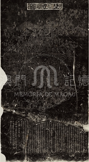
With “墬理圖(Di Li Tu)” as its original name, the Stele Map of Chinese Song Dynasty is one of the four national treasures conserved in Suzhou Museum of Inscribed Steles. The original painting was drawn by Huang Shang in 1190 AD. The cartographers Huang Shang(1146-1194) presented a total of eight maps with this map included to Zhao Kuo, the later Song Emperor, to remind him of the lost of the northern territory and of the determination of reunification. In the year of 1247 AD, Wang Zhi Yuan found this map in Sichuan Province,and then brought it back to Suzhou and engraved the map into the steles. In this way the map can be conserved till today.
This map depicted Song territory and administraion, being recognized as one of the four oldest national stele maps.This map illustrated the distribution of mountains, rivers, lakes in Song Dynasty, marking the hierarchical administration as Song governments, states, armies and Jian (the circuit justice). The Stone map has marked the border areas with more details, reaching to Heilongjiang and Changbai Mountain in the north, Hainan Island in the south, Yumen Gatein the west, and the coastal areas in the east. With the Yellow River and Shandong Peninsula precisely depicted, this map has a better understanding of the real origin of the Yangtze River than any other maps in Song Dynasty. It is worth mentioning that, although the place Macao is unknown by people in Song Dynasty, this ancient map has shown the prototype coastline of today, especailly the contour of the Pearl River Delta Estuary, and the southeast coast of Guangdong, and Fujian province.
Reference:
[1]. 青山定雄. (1940). 南宋淳祐石刻地理圖. 東方學報, 11(1).
[2]. 席會東. (2013). 南宋《墜理圖》中的南宋疆域政區. 載於中國古代地圖文化史. 北京 : 中國地圖出版社, 62-63.
[3]. 孫果清. (2006). 中國古代“輿地總圖”鑒賞. 文津流觴, (16), 36-39.

Informações relevantes
Data de atualização: 2020/09/08


Comentários
Comentários (0 participação(ões), 0 comentário(s)): agradecemos que partilhasse os seus materiais e histórias (dentro de 150 palavras).