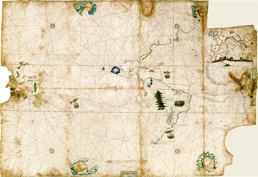
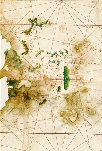
This planisphere is on a parchment measuring 146 x 209cm, has no title, no indication of the author, no date and is somewhat mutilated. It is a map of the Atlantic and Pacific Oceans. The Indian Ocean is missing but could have been on the other piece of the parchment that is lost today. It is certainly somewhat mutilated, because in the upper right of the map (oriented toward the East) was removed a rectangle of about 22 x 40cm and in the lower right corner was cut out another flap of about the same size but with curved contour, so as to give the impression that this right side is on the neck of the parchment. In this same part there is also a whole edge missing. On the opposite side, the planisphere is torn, with a large hole and several small ones in the leftside of the map. Another hole of considerable size is present in the part representing Africa. The planisphere's defects were caused primarily by humidity. Several inscriptions which are faded or worn are not readable. The planisphere is of the nautical kind, with only coastal place names represented and few inland indications. As with Ribero's, this planisphere probably came from a Padron real, but it is far less precise and not of the same quality. The anonymous author was very neglectful and had a rough manner of drawing, making errors in transcriptions, duplications, etc. The planisphere seems to have been copied by an Italian (perhaps Venetian) quickly, or with little care, from a pattern with place names and notes in Portuguese. The colors used are blue, black and red for the coastal names; red, green or blue for the islands, especially small ones; dark yellow or dark green for the mountains; light blue for rivers; a slight tint of light carmine for certain representations of towns or villages. In the Atlantic and Pacific Oceans some ships are depicted. At the edge of the map there is the description 'Insule Maluche'; with some of the islands of today's Philippines, such as 'Medanao,' 'Maton,' 'Cailon,' and 'Hunhan'; still other islands such as 'Ambon,' 'Timor,' and 'Maluca' are also represented. There is a strip of the Chinese coast with the dual inlet of Canton ('cantan' as on the map) and close to it a dozen other coastal names, among which the closest one might read 'macan' (today no longer legible with certainty), and another one described as '[...] Pescadores.'
Reference:
[1]. ALMAGIÀ, R. (1944). Planisferi, carte nautiche e affini dai secolo XIV al XVII esistenti nella Biblioteca Apostolica Vaticana. In Monumenta cartographica Vaticana (vol.1, pp.56-57). Città del Vaticano.
[2]. Pásztor, L. (1970). Biblioteca Apostolica Vaticana. In Guida delle fonti per la storia dell'America Latina negli archivi della Santa Sede e negli archivi ecclesiastici d'Italia, Collectanea Archivi Vaticani (vol.2, p. 601). Città del Vaticano.
Informações relevantes
Data de atualização: 2020/09/08


Comentários
Comentários (0 participação(ões), 0 comentário(s)): agradecemos que partilhasse os seus materiais e histórias (dentro de 150 palavras).