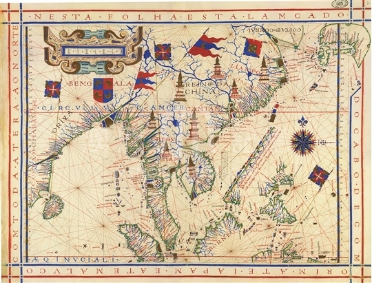
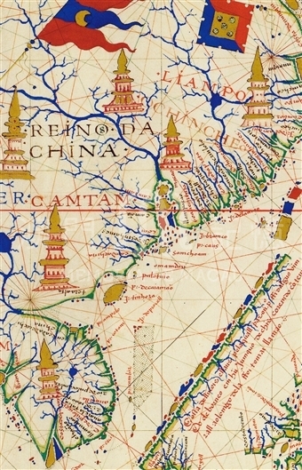
Born and grew in Goa, India, the Portuguese cartographer Fernando Vaz Dourado was very familiar with Asian geography. From 1568 to 1580, Dourado drew more than one atlas of the world, and at least six maps survive up till now. One of them is a relatively famous atlas painted by Dourado in 1571 in Goa, India. This atlas had a total of 20 maps originally, two of which have already been lost, and thus only 18 maps has been preserved, including a separate map of East Asia and Southeast Asia. This map is the map of East Asia in the atlas. The whole map is colorful and exquisite. Since the map completely abandons Ptolemy’s concept of Asian geography and makes the best of the new geographical knowledge acquired by Portuguese, it depicts the coastline of Southeast Asia and Southeast China relatively accurately. Macao was clearly marked in the east coast of the Pearl River estuary. However, the cartographer was not familiar with Mainland China, so he mistakenly marked Zhejiang and large surrounding areas as “Liampo” (today’s Ningbo). Dorado’s Atlas universal in 1570 is the first known map with 'Macao' marked on it. The map now is collected in the Huntington Library (San Marino) in the United State.
It is copied from Atlas universal from Macau University of Science and Technology Library. The original edition is from M. Moleiro Editor in 2001 copied from the precision limited edition of Arquivo Ncional da Torre do Tombo, Lisbon.
Reference:
[1]. Cortesão, A. (1960). Portugaliae monumenta cartographica (Vol. III, pp.17-22, plates 278-294). Lisboa.
[2]. Wolter, J. (1997). Images of the world : The atlas through history. Washington, D.C.: Library of Congress.
Informações relevantes
Data de atualização: 2020/09/09




Comentários
Comentários (0 participação(ões), 0 comentário(s)): agradecemos que partilhasse os seus materiais e histórias (dentro de 150 palavras).