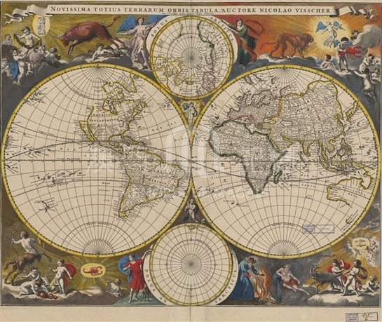
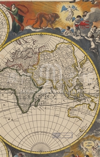
As one of the representatives of the Golden Age of Dutch cartography, the Visscher family had significant influence during that period. In the oil painting The Art of Painting by the contemporaneous Dutch master Johannes Vermeer, the map published by the Visscher family was used as the background. Nicolaes Visscher was the third generation of the family. This map was first included in Atlas Minor published by Visscher in 1679. Visscher portrayed two hemispheres by way of transverse projection and depicted the north and south poles by means of normal projection. Around the map were painted the images of 12 constellations in Western mythology, vivid and colorful, adding much beauty to the map. California was wrongly portrayed as a separate island, and the still unexplored east coast of Australia and Antarctica were left blank. Therefore, there are many errors or imperfections in the depiction of the new world. China was drawn on the right-most of the Eastern Hemisphere. Korea was properly portrayed as a peninsula. A small part of Japan appears on the Western Hemisphere. The shape of China is more accurate on the world map since Visscher fully absorbed the Chinese geographical knowledge brought back to Europe by Martini and other missionaries. In southern China, the map correctly depicts the Pearl River and its upper reaches. Guangzhou (Quangcheu) was labeled in Guangdong (Quantung) province. It is noteworthy that the map only painted the name and capital of each province, but “Macao” was marked in the coastal areas of Guangdong, demonstrating that Macau played an important role in global exchange and trade at that time. For the reason of the proportion, the map does not mark the exact location of Macau with symbols.
This map is copied from Atlas Minor published in about 1690; and the single map (G3200 1690 .V5) is collected in Harvard University Library.
Reference:
[1]. Debergh, M. (1983). A Comparative Study of Two Dutch Maps, Preserved in the Tokyo National Museum. Joan Blaeu's Wall Map of the World in Two Hemispheres, 1648 and Its Revision ca. 1678 by N. Visscher. Imago Mundi, Vol. 35, pp. 20-36.
[2]. Koeman C., & Van Egmond, M. (2007). Surveying and Offcial Mapping in the Low Countries, 1500-ca. 1670. In D. Woodward, editor, The History of Cartography (Vol. 3 : Cartography in the European Renaissance, pt. 2, pp. 1246-1295). Chicago: University of Chicago Press.
[3]. Welu, J. (1978). The Map in Vermeer's 'Art of Painting'. Imago Mundi, Vol. 30, pp. 9-30.
Informações relevantes
Data de atualização: 2020/09/09




Comentários
Comentários (0 participação(ões), 0 comentário(s)): agradecemos que partilhasse os seus materiais e histórias (dentro de 150 palavras).