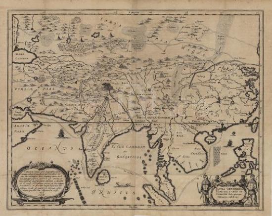
The mapmaker John Speed was the most prominent cartographer in the Stuart period of British history. Selected from the atlas of 22 maps “A Prospect of the Most Famous Parts of the World” published by Speed in London in 1627, the map here is the first world atlas made by the British. Having referred to the Chinese maps by Barbuda and Hondius, Speed painted China, Korea, Japan and the surrounding areas on his map. The map reflects the geographic information of the Ming Dynasty of Chinese history, but some place names were handed down from the age of Marco Polo. For example, northeast China was still called Cathaya (Khitan). The map reveals the cartography, topography, hydrology, etc. of China’s major provinces. There is a large island on behalf of Macau painted on the east coast of the Pearl River estuary, while Guangzhou (Cantaon) was incorrectly drawn on another large island depicted on the west coast. The eight drawings on the left and right side of the map portray figures of different genders and occupations from China and the neighboring countries. People of China was marked as “Chinian” instead of today’s “Chinese”. There are also four illustrations above the map, from right to left are respectively: first, Map of Japanese execution; second, a planmetric map of Beijing; third, a planmetric map of Macau; forth, map of travelling by Chinese wind-driven vehicle. The first and forth paintings both derive from the decorative pictures of Hondius’ map of China. The second one “a planmetric map of Beijing” was labelled “Xuntien al Quinzay”, i.e. “Shuntian or Xingzai”. According to the longitude and latitude of the map, the city is located at latitude 42.5 degrees, therefore it should refer to Beijing rather than Hangzhou mentioned in some materials. The third one “a planmetric map of Macau” was drawn with east at the top. Lianhuajing to Beaconsfield and Qingzhou Island to northwest corner are distinct. Macau is surround by ships on all sides, especially on the west side where enormous sailboats gather in the inner harbor, showing that Macau was a prosperous shipping port at that time. Lighthouse, churches and many European buildings were painted in the city, providing the basis for understanding Macau of the time. It should be noted that the atlas was made in 1626 and the map of China only contains two planmetric maps of Beijing and Macau, demonstrating that Macau was of great importance to western knowledge about China.
The original map is from the atlas “A Prospect of the Most Famous Parts of the World” by Speed in 1627, and the copy is from Harvard University Library (G1810 1626 .S6).
Reference:
[1]. Baynton-Williams, Ashley. (2014). John Speed. 20 July 2014 Retrieved from http:// MapForum.Com
[2]. Baldwin, R. (2007). Colonial Cartography under the Tudor and Early Stuart Monarchies, ca. 1480 - ca. 1640In D. Woodward, editor, The History of Cartography (Vol. 3 : Cartography in the European Renaissance, pt. 2, pp. 1754-1780). Chicago: University of Chicago Press.
[3]. Worms, L. (2007). The London Map Trade to 1640. In D. Woodward, editor, The History of Cartography (Vol. 3 : Cartography in the European Renaissance, pt. 2, pp. 1693-1721). Chicago: University of Chicago Press.
[4]. 鄧景濱. (2000). 澳門蓮系地名考. 澳門 : 澳門語言學會.
Informações relevantes
Data de atualização: 2020/09/09


Comentários
Comentários (0 participação(ões), 0 comentário(s)): agradecemos que partilhasse os seus materiais e histórias (dentro de 150 palavras).