

")


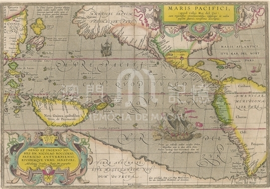
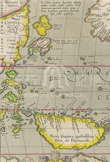
Theatrum Orbis Terrarum published in 1570 in Antwerp by Belgium cartographers Abraham Ortelius, (1527-1598) has been reputed to be the first modern atlas. This atlas contains 53 maps originally, and later Ortelius updated new maps continuously. In 1584, the atlas collected Barbuda’s New Map of China, and then in 1589, Ortelius, added the Map of the Pacific Ocean. The Strait of Magellan was marked on the map, on the bottom right of which depicts 'Victoria' Clipper, the only sailboat that returned successfully to Spain from 1519-1522 Magellan voyage around the world. This map combines the Europeans’ new knowledge about the Pacific, showing the dense islands on western Pacific Ocean. However, such errors appear on the map as the shortened distance between the north to the south the Pacific Ocean, resulting in the long and narrow shape of the Pacific Ocean in east west direction; and Japanese archipelago is too close to the North American continent and he mistakenly supposed that there was a huge piece of land near the South Pole. The Great Wall in northern China was marked with the length on the map. Provinces like 'Shandong' (Xanton), 'Zhejiang' (Cequiem) and 'Fujian' (Foquiem) were also marked, and on the Pearl River Estuary appears not only Guangzhou (Cantao) but also tall buildings. The map didn’t painted Liaodong Peninsula and the Korean Peninsula, and the eastern coastline of China was wrongly drawn as a straight line.
It is copied from Theatrum Orbis Terrarum (1605, English edition) from Harvard University Library.(MO 1.1606 pf).
Reference:
[1]. Ortelius, A. (1606). Theatrum orbis terrarum Abrahami Orteli Antverp : The theatre of the whole world. London: Iohn Norton.
[2]. Ortelius, A. (1950). Maris Pacifici (quod vulgo mar del zur) cum regionibus circumiacentibus, insulisque in eodem passim sparsis, novissima descriptio. St. Louis.
Informações relevantes
Data de atualização: 2020/09/09

Comentários
Comentários (0 participação(ões), 0 comentário(s)): agradecemos que partilhasse os seus materiais e histórias (dentro de 150 palavras).