

")


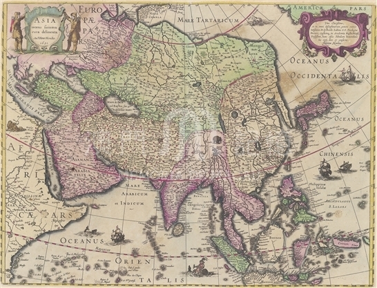
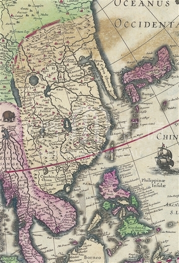
The mapmaker Henricus was the son of the well-known Dutch cartographer Jodocus Hondius. Henricus took over the map-making business of Hondius family after his elder brother and mother passed away in 1629. He worked with his brother-in-law (Joannes Janssonius, 1588-1664) and continued to draw and publish the atlas. With the developing of Westerners’ exploration of East Asian coast areas, their knowledge of the East Asian coastline was also more abundant and accurate, which was reflected in the drawing of maps. The map here was one of the most detailed and accurate maps about Asia in early 17th century Europe. It depicts in detailed rivers, mountains, islands and marks more cities and towns than ever before. Korea was adjusted from an island in the earlier maps to a peninsula linking with Northeast Asia continent. There are illustrations of mermaid and monster in Indian Ocean, elephants in South Asia, lions in East Africa as well as Chinese junks and European merchant ships cruising on all waters, thus the map seems to be an interesting story. The map makes further improvements in portraying Chinese coastline: coastline south of Ningbo cape is more close to the actual shape and Shandong Peninsula and the Bohai Bay begins to take shape but they are much smaller than the actual situation; waters near the first island chain east of the Japanese archipelago and the Ryukyu Islands was labelled as “Chinese Ocean” (Oceanus Chinensis). Nevertheless, the depiction of inland China remains a serious distortion and China’s major river was drawn to connect with each other. The map provides more detailed geographic information along the Pearl River estuary. The position of Guangzhou (Cantao) was revised to locate in the most northerly area of the Estuary. “Macao” was written on the land of east of the Pearl River estuary, while the symbol representing Macau was painted on another island outside the estuary. It should be pointed out that the surrounding islands of Macau, the Cross Gate and the large and small Hengqin islands are already faintly discernable.
This map is copied from the 1633 French edition of Johannes Janssonius’ Atlas, ou Represéntation du monde universel et des parties d’icelui, faicte en tables et descriptions collected in Harvard University Library. (MM 1.1633.2 pf)
Reference:
[1]. Keuning, J. (1947). The History of an Atlas: Mercator - Hondius. Imago Mundi, Vol. 4, pp. 37-62.
[2]. Van der Krogt, P. (1996). Amsterdam Atlas Production in the 1630s: A Bibliographer's Nightmare. Imago Mundi, Vol. 48, pp. 149-160.
Informações relevantes
Data de atualização: 2020/09/09
Comentários
Comentários (0 participação(ões), 0 comentário(s)): agradecemos que partilhasse os seus materiais e histórias (dentro de 150 palavras).