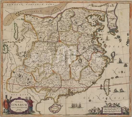
This map was included in the Volume III of the six-volume “New Atlas” (Nieuwen atlas, 1657-59) drawn by Johannes Janssonius (1588- 1664). The Dutchman Janssonius was the son-in-law of Jodocus Hondius. He published many atlases with his brother-in-law Henricus Hondius and took over the entire map-making business of the Hondius family after 1647. The New Atlas published by Janssonius contains maps of hundreds of cartographers, including this Map of China by Johannes van Loon. Van Loon was a Dutch mathematician, astronomer and cartographer. He painted maps for Janssonius over a long period of time. Van Loon referred to Martini’s Novus Atlas Sinensis when drawing this map, but he omitted large areas at the top and depicted only a small part of the Japanese archipelago. The map reflects the geographic information of the Ming Dynasty of Chinese history. “Macao” was written on the eastern waters of the Pearl River estuary with no symbol to mark the specific location, and many of the islands around Macau have been left out. From 1581 to 1640, Portugal was governed by Iberian Union (union of Spain and Portugal). Meanwhile, the booming Kingdom of the Netherlands was stepping up its military expansion in the Far East. The Dutch warships often appeared in the waters near Macao with the intention to occupy Macau or to intercept merchant ships trading in Macau. Therefore, armed conflicts often occurred between Dutch warships and Spain-Portugal fleet. Many scholars believe that the fighting European warships drawn outside the Pearl River estuary reflect that period of history. In the lower left corner there are images of four Europeans wearing Chinese-style clothes, which vividly reflects that Europe had established direct links with China, mainly with Macau as the hub. A group of Mermaid-shaped angels in the lower right can be described as vivid and pretty cute.
This map is copied from the single map collected in Harvard College Library. (G7810 1657.L6) The original atlas collected in National Maritime Museum in Amsterdam.
Reference:
[1]. Keuning, J. (1951). The Novus Atlas of Johannes Janssonius. Imago Mundi, Vol. 8, pp. 71-98.
[2]. Van der Krogt, P. (1996). Amsterdam Atlas Production in the 1630s: A Bibliographer's Nightmare. Imago Mundi, Vol. 48, pp. 149-160.
[3]. [ 美] 諾埃爾. (1979). 葡萄牙史. 北京: 商務印書館.
[4]. 吳志良, 湯開建&金國平. (2009). 澳門編年史. 廣州市: 廣東人民出版社.
Informações relevantes
Data de atualização: 2020/09/09


Comentários
Comentários (0 participação(ões), 0 comentário(s)): agradecemos que partilhasse os seus materiais e histórias (dentro de 150 palavras).