

")


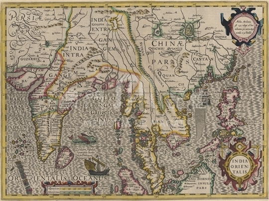
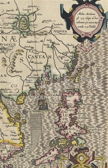
Jodocus Hondius was the founder of the Hondius family, a famous map-making family in 17th century Netherland. In 1604, he acquired the mapmaking copper plate used by Mercator and started to produce new atlas. His “Gerardi Mercatoris Atlas” was first published in Amsterdam in 1606. On the basis of the original atlas by Mercator, he added 36 new maps, of which the map here was one. Afterwards, the atlas was reprinted and added new maps continuously, but the original copy of “Map of India Orientalis” by Hondius had been used for a long time. Having referred to the India map made by Petrus Plancius (1552-1622) in 1594, this map portrays the geographical information of Indian, Ceylon, the Malacca Strait, Borneo (now Kalimantan in Indonesia), Luzon (Philippines) and southern China, remaining as one of the earliest Dutch maps about those regions. Along the coast of southern China, from west to east appears Guangxi (QUANCII), Hainan Island (I. Ainam), the Pearl River estuary, Guangzhou (Cantao), Macau (Macao) as well as the island of Taiwan (I. Fermosa). Cochinchina (now northern Vietnam) was also depicted within Chinese boundaries. The title and scale were painted with beautiful scroll ornamentation and decorated with sea monsters, ships and other patterns. Around 1601, armed merchant ships of the Netherlands arrived in Chinese waters and intended to enter the Pearl River estuary to pay tribute to Chinese emperor, leading to nearly three decades of battle for Macao against Portuguese. Until 1627, Dutch troops gave up the intention to occupy Macao and invaded Taiwan instead after all the five invasions of Macao had failed. The images of Dutch warships drawn in the Pearl River estuary reveal that period of history. In 1641, the Dutch captured Malacca from Portuguese and cut off the ship route from Goa in India to Macau. Therefore, the trade from Portugal to China was no longer secure and the Portuguese empire in its heyday began to decline gradually.
This map is copied from the atlas “Gerardi Mercatoris Atlas”pubilshed in 1630 collected in Harvard University Library.(G7400 1630 .H6)
Reference:
[1]. Fite, E. (1926). A book of old maps : Delineating American history from the earliest days down to the close of the revolutionary war. Cambridge: Harvard University Press.
[2]. Keuning, J. (1947). The History of an Atlas: Mercator - Hondius. Imago Mundi, Vol. 4, pp. 37-62.
[3]. [ 荷] 伽士特拉. (2011). 荷蘭東印度公司. 上海市 : 東方出版中心.
[4]. 趙文紅. (2012). 17世紀上半葉歐洲殖民者與東南亞的海上貿易. 昆明市:雲南人民出版社.
Informações relevantes
Data de atualização: 2020/09/09
Comentários
Comentários (0 participação(ões), 0 comentário(s)): agradecemos que partilhasse os seus materiais e histórias (dentro de 150 palavras).