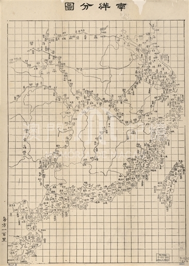
The map depicts the geographic features of coastal lines and districts along rivers in nearly ten provinces in southeast China under the jurisdiction of Nantah Ministers. It begins from Rizhao, Shandong in the north to the south edge, Qinzhou and Yuzhou located in the most west in Guangdong, including Taiwan and Hainan Islands. The depicture lays more emphasis on areas along the seas and rivers than on other places like inner continent, the marking of which is rather simple instead. The symbols of types used on the map stand for administrative districts of different classes, for example, the frame of “回” stands for provincial capitals, the square stands for prefectures, the diamond for eparchies, circle for counties and solid circle for grounds, bureaus and passes. The scattering of mountains is drawn in visualized symbols. The drawing of coastal areas in Guangdong is laid much emphasis on the map, one quarter to the bottom left of which lies the Pearl River Estuary. Macau is drawn as a large island, with Censer Mountain in the north. To the north the Xiangshan County is categorized into another island separated from the Peninsula by a narrow water channel. The area of the latter on the map is almost three times of the former, which is obviously not the case. To the east of Macau, small islands are densely spread, with a sign Jiu Xing Yang beside on it. When the map was completed Hongkong then had already been a trade port for decades, yet it is not shown. To the east of Jiu Xing Yang, one large island is marked as Da Ao, which should be Lantau today. The water channel between Hongkong islands and it is marked as Rapids Gate. Rarely seen is that on a big island to the southwest of Macau there is a mark “Saint’s Tomb”, the owner should be referred to St.Francis Xavier. There are grid lines constituted by vertical and horizontal straight lines, with each check marked as 100 knots. The precision of distances among all places and their proportions has been greatly improved, there’re lots of invalid markings, though. It’s a pity that, given that in 1870, the western surveying and mapping technology had been introduced into China over 200 years, the development of cartography of china is still slowing that only left a sigh.
This map is a copy of the Coastal Map of the South China “G78201870.H8” preserved in the Library of Congress, U.S.A.
Reference:
[1]. 林天人編撰; 張敏英文編譯. (2013). 皇輿搜覽 : 美國國會圖書館所藏明清輿圖 ( pp332). 臺北:中央研究院數位文化中心; Washington D.C. : 美國國會圖書館.
[2]. 廣東歷史地圖集編輯委員會編. (1995). 廣東歷史地圖集. 廣州:廣東省地圖出版社.

Informações relevantes
Data de atualização: 2020/09/09


Comentários
Comentários (0 participação(ões), 0 comentário(s)): agradecemos que partilhasse os seus materiais e histórias (dentro de 150 palavras).