

")


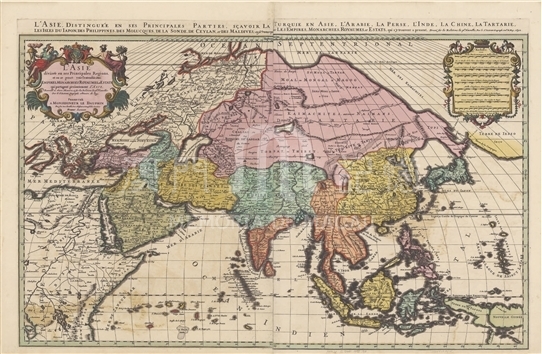
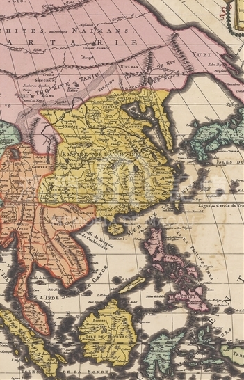
Guillaume Sanson is the son of Nicolas Sanson who is known as the “father of French cartography”. After the death of his father, Guillaume followed in his father’s footsteps and co-published maps with the new royal cartographer Hubert Jaillot (1632? -1712). The maps of the Sansons boasted of its preciseness, and Jaillot added rich artistic elements to the maps. Therefore, the publication of the maps marked the rise of France cartography. Based on his father’s map of Asia, Guillaume painted this map by integrating a variety of geographic information. Asia in the map stretches from the west coast of the Pacific in the east to Asia Minor in the west. There are a lot of mistakes in the shape of the northeast corner of Asia because the Bering Strait had not been discovered yet at that time. Up till then the westerners had been sailing to the East for nearly two hundred years, so the portrayal of the Arabian Peninsula, the South Asian subcontinent and Southeast Asia was very accurate. However, the depiction of China still relied on the knowledge of Martini and other missionaries in the late Ming Dynasty. Although the map was finished and published during Kangxi’s reign in the Qing Dynasty, it reveals actually the geographical information of the late Ming Dynasty. In addition to Quancheu (Guangzhou), Hoeicheu (Huizhou), Nanhuing (nanxiong), Xaochwu (Xaucea), Chanking (Zhaoqing) and other cities were also marked from east to west in QUANGTUNG (Guangdong) Province, but the positions of two cities with similar names Caocheu (Chaozhou) and Gaocheu (GAOZHOU) were interchanged. “Macao” was written on the waters outside the Pearl River estuary and to the left of the word appears an explicit symbol that obviously refers to Macau. Many small islands around Macau are faintly visible, and in the southwest direction of Macau was marked “Sanchoan” which should refer to Shangchuan Island, but there is no distinct symbol.
The Map of Asia by Guillaume Sanson was first published in 1683 and was reprinted consecutively. This map is copied from the single map published in 1692 from Harvard Map Collection. (G7400 1692 .S3)
Reference:
[1]. Szczesniak, B. (1956). The Seventeenth Century Maps of China: An Inquiry into the Compilations of European Cartographers. Imago Mundi, Vol. 13, pp. 116-136.
[2]. Pastoureau, M. (1980). Les Atlas Imprimés en France avant 1700. Imago Mundi, Vol. 32, pp. 45-72.
[3]. 金國平編譯. (2005). 西方澳門史料選萃: 15-16世紀. 廣州:廣東人民出版社.
Informações relevantes
Data de atualização: 2020/09/09

Comentários
Comentários (0 participação(ões), 0 comentário(s)): agradecemos que partilhasse os seus materiais e histórias (dentro de 150 palavras).