

")


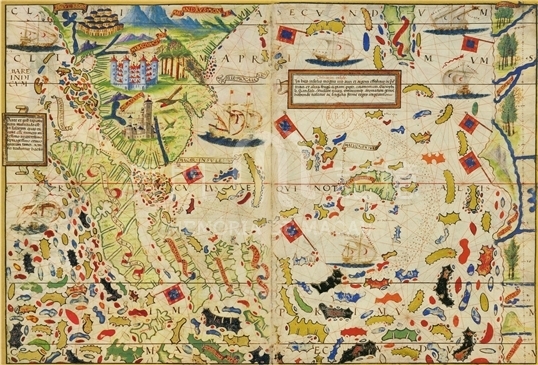
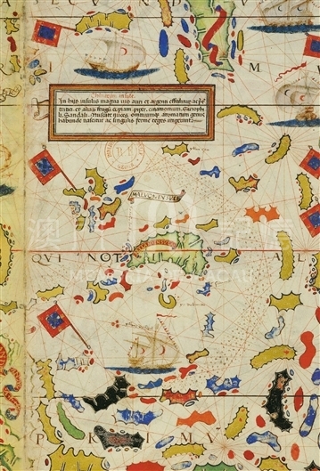
As one of “The Miller Atlas”, this map painted the most part of the actual geographic shape of the Southeast Asia. The southernmost area of Malay Peninsula was drawn in such an exaggerate way as the round bottom of Pottery Cauldron. The Title of Singapore (Simgapura) was marked on Malay Peninsula, and with the precise location marked. The other two cities were marked on Malay Peninsula; the southernmost one as “Malaqua”, and the red castle slightly north as “Mabaqua”. In fact, they both referred to the same city, Malacca, known as a transportation junction and trading center after being dwelled by Portuguese in 1511. The mapmaker failed to distinguish the names of Malacca passed through various channels in different times and he mistakenly assumed that “Malaqua” and “Mabaqua” were two different cities. Above the mark of the Maluku Islands, a note is attached to explain the new-discovered riches of the Chinese Islands (Chinarum Insule) reads, “Chinarum insule: in his insulis magna uis auri et argenti effo- ditur, ac praeter tritici et aliorum frugum copiant, piper, cinamomum, gario- phili, sandali, muscate nuces, omniumque aromatum genus habunde nascitur ac singulis ferme reges imperant.”1 (These islands are rich in gold and silver, also large amounts of grain, fruit, pepper, Cinnamon, Scandalwood and nutmeg. Here grows a great variety of perfume. The King has a very powerful rule over its subjects.) As to the content of the note, the passage describes the islands of Southeast Asia with preciseness, while in the eyes of the mapmaker those islands obviously belonged to “Chinese Islands”. A large land area and three Portuguese flags were painted on the rightmost of the map. That way of depicting the rich land is from the imagination of mapmaker on the basis of possible various hearsays, for such a depicted land in the Pacific Ocean does not exist in the real world. The reason why the mapmaker painted such land area is still under discussion.
It is copied from the collection of 'Miller Atlas' from Macau University of Science and Technology Library, and the replica is from M. Moleiro Editor's limited edition copy originated from the French National Library in 2003.
Reference:
[1]. Miró, M. (2006). Atlas Miller. Barcelona: M. Moleiro Editor.
[2]. Shirley, R. W. (1983). The mapping of the world: Early printed world maps, 1472-1700.London: Holland Press.
[3]. 龔纓晏. (2011). 《米勒之地集》之謎. 地圖, 02期.
Informações relevantes
Data de atualização: 2020/09/09
Comentários
Comentários (0 participação(ões), 0 comentário(s)): agradecemos que partilhasse os seus materiais e histórias (dentro de 150 palavras).