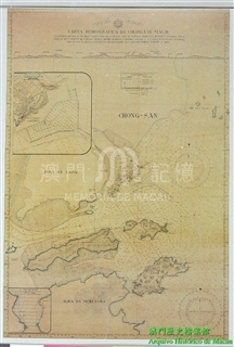
James Cook, a well-known British navigator, explorer and map designer, steered his teams along Pacific Ocean three times. On his third voyage, Cook died in a clash with natives in Hawaii and his fleets reached Macau in 1780 on a homeward voyage. William Bligh (1754- 1817), a sailing master, then mapped Macau and its surrounding channels and it is William Harrison (about 1750-1803) who mad the map when first published, it was kept in a log, “Voyage to the Pacific Ocean” onboard, which was later printed in many different publications. On top left of the map are decorated some drawings, British flags, anchors, rudders and cannons. The geographic situations of Macau and Typa, Coloane and Hengqin Islands around are all under detailed descriptions. It should be noted that Typa is not Taipa today but the water way constituted by Taipa, Coloane and small Hengqin Island in Cross Gate water area. To the southeast of Macau Peninsula, the waterway leading to Guangzhou is marked as Macao Road. Though it is a so-called draft without Meridian and Parallel, the accurate location of Typa is marked out, north latitude 22°9′, east longitude 113°48′. On the bottom there’s a scale, the topographical heights of islands, depths of navigation channels, anchoring and watering places and some other important spots are marked out, which is obviously made under careful surveying and mapping. Below the title are marked changes of tides in Macau courses following the lunar phases. When Moon is full, water rises six inches at 5:15, Typa and at 5:50 the tide reaches its height in Macao Harbour. Notices in navigation are listed out in references.
This map is a copy from Harvard University. Library map Collection, call number G7822 .T27 178- .H6.
Reference:
[1]. Cook, J., & King, J. (1784). A voyage to the Pacific Ocean: Undertaken by command of His Majesty, for making discoveries in the northern hemisphere, performed under the direction of Captains Cook, Clerke, and Gore, in the Years 1776, 1777, 1778, 1779, and 1780. London: Printed for J. Stockdale, Scratcherd and Whitaker, J. Fielding, and J. Hardy.
[2]. Kitson, A. (1907). Captain James Cook. New York, E. P. Dutton & company.
[3]. David, A., Joppien, R., Smith, B., & Australian Academy of the Humanities. (1988). The Charts & coastal views of Captain Cook's voyages. London: Hakluyt Society in association with the Australian Academy of the Humanities.

Informações relevantes
Data de atualização: 2020/09/09






Comentários
Comentários (0 participação(ões), 0 comentário(s)): agradecemos que partilhasse os seus materiais e histórias (dentro de 150 palavras).