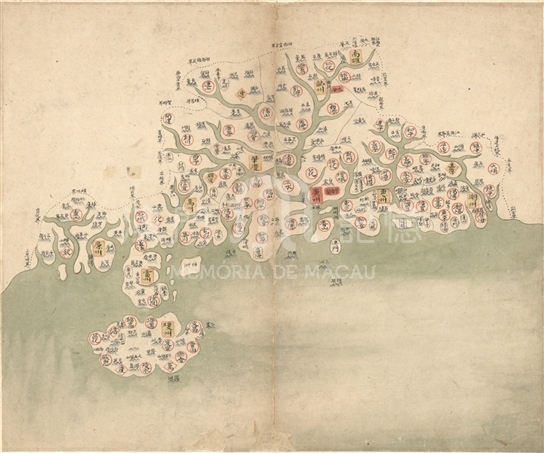
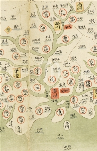
This map is from the sixteenth piece from Provincial atlas of the great Qing Dynasty, without an original name. In the map, dotted lines stretch out provincial boundaries, while thin solid lines draw the outline of state territory. Meanwhile, different administrative areas and grade division are displayed in various graphic symbols and background colors: boxes for “Fu” (one administrative government, with an equivalence of provinces now), diamonds for “Zhou” (equal to city), and circles for counties; for the colored background, red for the first-ranked provincial government, yellow for the second-ranked Fu and Zhili Zhou (municipality), while colorless indicates the third-ranked county and state. This map vividly depicts mountains in Guangdong Province, noted with the allusions and stories of the places. The map full demonstrates the profound Pearl River. However, due to the lack of proportion concepts, the mapmaker mistook the percentage of the channel width and land. Chaozhou, Huizhou and Jiaying were painted as a whole island. Meanwhile, Lianzhou, Sanshui, Xiangshan and Macau were also drawn as islands instead of the precise inlands and peninsulas. Guangzhou, the provincial government, was marked with a red box, with a note of “Pearl River” below the waterway. This drawing method showed the different connotation of the word of “Zhujiang (the Pearl River),” which only referred to one section of the waterway from Guangzhou to the mouth of the River. It is noteworthy that Guangdong Customs was specially marked, indicating the mapmaker’s emphasis on sea trade. As can be seen from the map, Xiangshan County was under the administration of Guangzhou government, with “Macao” marked on its southeast sea. There were two mountains, “Sanzhou” and “Hengqin”, on the south part of sea near Macau. Also due to the lack of proportion and mathematical concepts, the distance between Macau and Hengqin were wrongly painted with almost equivalent to the entire length of the Leizhou Peninsula. This inaccurate mapping is also an important proportion of characteristics of ancient Chinese maps.
This map is the sixteenth one of “Provincial atlas of the great Qing Dynasty,” from the Library of Congress in United States (G2305. D35 1760).
Reference:
[1]. 林天人編撰; 張敏英文編譯. (2013). 皇輿搜覽 : 美國國會圖書館所藏明清輿圖 (pp79-82). 臺北 : 中央研究院數位文化中心; Washington D.C. : 美國國會圖書館.
[2]. 牛平漢主編. (1990). 清代政區沿革綜表. 北京:中國地圖出版社.
[3]. 《中國河湖大典》編纂委員會編著. (2013). 中國河湖大典 : 珠江卷. 北京: 中國水利水電出版社.
Informações relevantes
Data de atualização: 2020/09/09


Comentários
Comentários (0 participação(ões), 0 comentário(s)): agradecemos que partilhasse os seus materiais e histórias (dentro de 150 palavras).