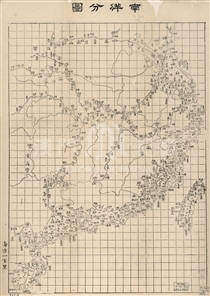
In ancient China, there was a kind of one-sheet historical map. The ancient geographical knowledge was noted on the 'modern' maps of the mapmakers, and some notes about the geographical postures are also added. This kind of map is mainly used in the education of history. The earliest existent map of this kind is the Gu Jin Xing Sheng Zhi Tu (古今形勝之圖) which was re-carved in Jinsha Academy in Fujian in 1555. According to the inscription on the map, it was authorized by Gan Gong, who was born in Xin Feng, Jiangxi. Gu Jin Xing Sheng Zhi Tu was gained by the Spanish in the far east, and submitted to the Philip II in 1574, now collected in the Archivo General de Indias in Sevilla, Spain. Zhang Huang's Collections of Maps and Books was printed in Wanli Period of Ming Dynasty, this map may probably derived from Gu Jin Xing Sheng Zhi Tu. Both the extension and notes are very similar on these two maps. However this map in Tu Shu Bian was stretched in Eastwest direction, and was divided into four pages. Some details on the map such as the drawing of rivers, lakes and coastlines are also different, eg. the Shandong Peninsula, the Tai Lake, the Poyang Lake, and the Dongting Lake. The coastline of Guangdong was largely out of shape. The Pearl River and Leizhou Peninsula are omitted, and the coastline of the middle and western part of Guangdong looks like a concave bay. There are two large islands in that bay. The west and larger one is Hainan Island, the east and smaller one is Xiangshan Island which situated to the south of Guangzhou City, which is marked with a note 'Wen Tianxiang sailed across Ling Ding Yang Sea'. This map reflects the traditional Chinese view of the world in that era. China stayed in the middle of the world when foreign countries were located surrounding the edge. And some records about the foreign countries on the ancient Chinese history books are quoted. Comparing with the Yu Di Tu Shang (輿地圖上) in this album, we can see the totally difference between Chinese and western geographical conceptions from this map.
Reference:
[1]. 金國平. (2014). 關於《古今形勝之圖》作者的新認識. 文化雜誌, 93, 149-162.
[2]. 海野一隆. (2004). 汉民族社会における歴史地図の変迁. 東洋地理學史研究·大陸篇. 大阪: 清文堂, 58-109.
Anotações: 選自《圖書編》
Informações relevantes
Data de atualização: 2020/09/08


Comentários
Comentários (0 participação(ões), 0 comentário(s)): agradecemos que partilhasse os seus materiais e histórias (dentro de 150 palavras).