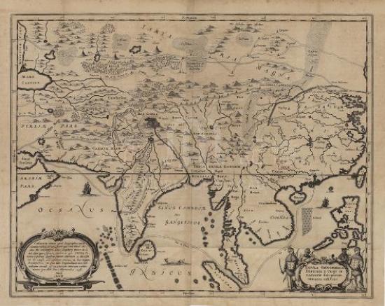
This map is selected from the Latin version of Theatrum orbis terrarum, sive atlas novus published in 1635. After the Dutch came to the East, China had captured their attention. From around 1601, the Dutch and Portuguese had nearly three decades of battle for Macao until 1627, when the Dutch troops gave up capturing Macao and instead invaded Taiwan after all the five invasions of Macao had failed. In 1642, the Dutch forces attacked Spanish colonial army in Taipei and expelled them from Taiwan. From then on, Taiwan Island was monopolized by the Dutch colonists until it was recaptured by Zheng Chenggong in 1661. Therefore, the Dutch had a relatively good understanding of Macao, Taiwan and other coastal areas. Many errors in the previous maps drawn by Europeans turned to be precise in this map. Macao was correctly drawn near the islands on the west coast of the Pearl River for the first time and Taiwan Island was portrayed as a large island instead of three small separate islands. In northern China, the Great Wall was painted with a text description. However, many inland areas of China were not correctly depicted in this map, especially China’s inland river systems and lakes. In addition, the Korean peninsula was wrongly portrayed as an independent island.
This map is a copy of the single map (G7810 1635 .B5) from the Map Collection Department of Harvard University Library. It is collected in the Blau’s Theatrum orbis terrarum, sive atlas novus 1635, Volume 2, No.188.
Reference:
[1]. Schilder, G., & Blaeu, W. J. (1990). Monumenta cartographica Neerlandica (Vol. 3,4). Alphen aan den Rijn: Canaletto.
[2]. Koeman, C., & Blaeu, J. (1970). Joan Blaeu and his grand atlas. Amsterdam: Theatrum Orbis Terrarum.
[3]. Koeman, C. (1969). Atlantes Neerlandici (Vol. 2). Amsterdam: Theatrum orbis terrarum.
Informações relevantes
Data de atualização: 2020/09/09


Comentários
Comentários (0 participação(ões), 0 comentário(s)): agradecemos que partilhasse os seus materiais e histórias (dentro de 150 palavras).