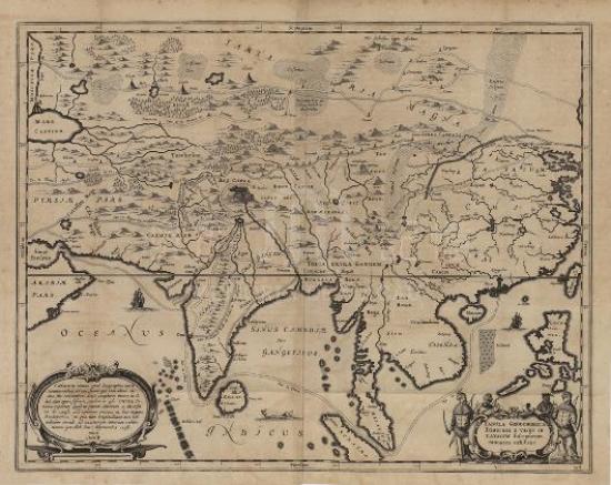
Born in the cartographer Teixeira Albernaz family, João Teixeira Albernaz was the most fruitful in Portuguese cartography in 17th century. By employing watercolor on the upper part, the map decorates such geomorphology and hydrology in northern Asia as mountains, bays, rivers and trees with painting skills. The map adopts Mercator projection, so the outline of the northern region is obviously widen. This map uses scale and compass, and also depicts the north Asia to the equator and the adjacent waters, including the western Pacific Ocean and the Indian Ocean. Its focuses on coastline and islands and marks the coastal cities, while the inner land is less emphasized. It has the influence of the early Western Chinese map, fully depicting the south of 'Liãopoo'(Ningbo cape); on the contrary, its north has little mention, even without the major river nor its distribution. But the Great Wall is noted as the ' muro da china ' (Chinese wall). The map has made great progress on those depicts of the northern coastline the Yangtze River, rather than a straight line, and on accurate outline of Shandong (Xantun) peninsula, Bohai Bay and the Liaodong Peninsula. In the Pearl River estuary draws a large number of islands with various colors. Macao is marked on the east coast of the Pearl River estuary, while the Cantão (Guangzhou) to the northwest of Macao, which reflects the early notions that Macao was on the east coast of the Pearl River estuary. This mistake is due to two reasons: one, the Pearl River is wide; two, Modaomen, on the west of Macao was the gateway to Xijiang River, and then via the Pearl River to Guangzhou. This is another evidence of map’s reflecting historic ideas.
This map is the twelfth sheet from the 31 maps from Taboas geraes de toda a navegação in the Library of Congress (G1015 .T4 1630).
Reference:
[1]. Library of Congress. (2011). Taboas geraes de toda a navegação. 21 August 2011 Retrieved from http://www.loc.gov/item/78653638
[2]. Dias, M. & Botelho, H. (1999). Quatro séculos de imagens da Cartografia portuguesa = Four centuries of images from Portuguese Cartography (2 ed.). Lisboa: Comissão Nacional de Geografia [etc.].
[3]. [ 美] 亨特(Hunter, W.)著;冯树铁译. (1993). 广州“番鬼”录 : 1825-1844缔约前“番鬼”在广州的情形. 广州市:广东人民出版社.
Informações relevantes
Data de atualização: 2020/09/09


Comentários
Comentários (0 participação(ões), 0 comentário(s)): agradecemos que partilhasse os seus materiais e histórias (dentro de 150 palavras).