

")


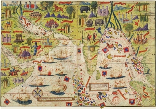
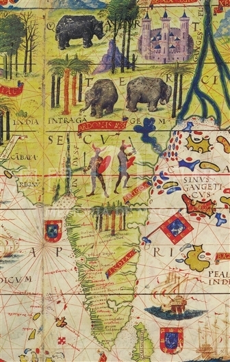
At the end of 19th century, National Library of France in Paris acquired a precious hand-painted atlas, and the name of “The Miller Atlas” was derived from Miller, who owned the atlas as a personal asset for the last decades. The three most famous cartographers in Portugal made the atlas: Lopo Homem, Pedro Reinel and his son Jorge Reinel. The atlas we see now contains four pieces of parchment and there is a map on either side of each parchment, therefore the atlas has a total of eight maps (The size of each map is 410x590mm). The eight maps are respectively “Map of Northern Indian Ocean”, “Map of the North Atlantic Ocean”, “Map of Brazil”, “Map of East India”, “Map of Europe”, “Map of the Azores Archipelago”, “Map of the Mediterranean Sea” and “Map of Madagascar”. The original atlas should include the whole world, while some maps in the atlas including of Africa may have been lost. Portuguese had explored the northern Indian Ocean for twenty years and gradually established its colonial hegemony before The Miller Atlas came out, thus the vast area from the Red Sea to the Strait of Malacca was clearly marked on this map. The brightly colored islands on Indian Ocean actually refer to today’s Maldives. To draw the attention of sailors, an explanatory note in the box “This area has rich magnet, so it affected ships what with iron nails stoped in this region.” On the bottom right of the map, “Nicobar” was marked on the sea close to the mouth of the Strait of Malacca and its position on the map was similar to that on modern map. Today’s Sumatra was marked as “Tower park Robben Island”, which was discovered in ancient times and was regarded as the largest island in the East. The name“Tower park robben island” was marked confusedly on many maps, referring to Sri Lanka or Sumatra, while on this map Sri Lanka and Sumatra were clearly marked on different positions. The strait located north of Sumatra is the Strait of Malacca, the shape of which was relatively correctly painted. The map was the product of Portuguese’s exploration on the Indian Ocean over a long period of time.
It is copied from the collection of Miller Atlas from Macau University of Science and Technology Library, and the replica is from M.Moleiro Editor's limited edition copy originated from the French National Library in 2003.
Reference:
[1]. Miró, M. (2006). Atlas Miller. Barcelona: M. Moleiro Editor.
[2]. Shirley, R. W. (1983). The mapping of the world: Early printed world maps, 1472-1700. London: Holland Press.
[3]. 龔纓晏. (2011). 《米勒之地集》之謎. 地圖, 02期.
Informações relevantes
Data de atualização: 2020/09/09

Comentários
Comentários (0 participação(ões), 0 comentário(s)): agradecemos que partilhasse os seus materiais e histórias (dentro de 150 palavras).