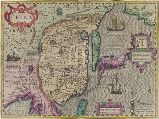
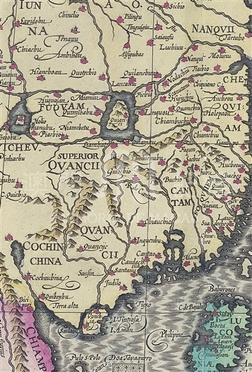
This map was first included in the 1606 edition of Gerardi Mercatoris Atlas by the famous Dutch cartographer Jodocus Hondius, and it has been regarded as another important single map of China following Luiz Jorge de Barbuda’s map (Chinae: olim Sinarum regionis, noua descriptio). Apparently, Jodocus had referred to Barbuda’s map, but the azimuth in Barbuda’s map was adjusted to customary “north points up and south points down”. In the map, China was still portrayed in the shape of a rectangular, the coastline trend of which was broadly in line with that in early Portuguese’ maps: the basic trend of the coast from Guangdong to Fujian is from southeast to northeast and the coastline from Fujian to Beijing is chiefly a straight line from south to north. The map marks the general area of various provinces. The positions of coastal provinces are basically correct, but there are many errors in inland provinces. For instance, Sichuan was omitted, Yunnan(IUNNA)was labelled in Sichuan’s position instead. Guizhou (QVICHEV) was marked in Yunnan’s position and superior Guangxi (SUPERIOR QVANCII) was labelled in Guizhou’s position, then to the south of superior Guangxi was marked Guangxi (QVANCII). The map was colored by hand and different colors were used to distinguish between China and its neighboring countries. Cochinchina (now northern Vietnem) was depicted in Chinese territory. Symbols were painted to identify cities. The symbol on behalf of Macau (Macao) was portrayed on the east coast of the Pearl River estuary and the sign of Guangdong (Cantao) was drawn on the west coast. The coastline of northern China was improved with Bohai Bay plotted, while the entire coastline is still too straight. The outline of Japan is more accurate than that in earlier maps. The long and narrow shape of Korean peninsula might inherit influence from such Chinese maps in Ming Dynasty as Gu Jin Xing Sheng Map. A small land was painted in the northeast corner of the map to stand for America. Hondius added a lot of new information to the map as well as adopted the notes in Barbuda’s map of China. On the left side of the map appears legendary Chinese wind-driven vehicle with the note praising Chinese people’s genius of making a vehicle driven by wind power to drive on the ground like sailing on the sea. On the North of the Great Wall, a description of “asbestos showing that from mountains fine fibers are exploited. The fibers can be woven into cloth that will not be burnt in fire. ”Beijing region was noted as “Shun Tian, the city of heaven, so Chinese emperors build the capital here. ”Japanese criminal penalty was depicted beside Japan with notes explainning that“the cross is made up of four pieces of wood without nails. Culprits’ hands and feet were tied to the cross with rope and executioner put the spear into their right ribs. Some Christians died in this way because of faith in God.”
This map was later included in Atlas, ou Represéntation du monde universel et des parties d 'icelui, faicte en tables et descriptions by Johannes Janssonius (1588-1664), and was copied from the French Edition (1633) collected in Harvard Library. (MM 1 .1633 .2 pf)
Reference:
[1]. Keuning, J. (1947). The History of an Atlas: Mercator - Hondius. Imago Mundi, Vol. 4, pp. 37-62.
[2]. Potter, J. (1988). Country life book of antique maps : an introduction to the history of maps and how to appreciate them. London : Country Life Books. pp 123.
[3].周振鶴. (2003). 西洋古地圖裏的中國. In 周敏民編, 地圖中國. 香港 : 香港科技大學圖書館.
[4].金國平. (2000). 西力東漸:中葡早期接觸追昔. 澳門 : 澳門基金會.
Informações relevantes
Data de atualização: 2020/09/09




Comentários
Comentários (0 participação(ões), 0 comentário(s)): agradecemos que partilhasse os seus materiais e histórias (dentro de 150 palavras).