

")


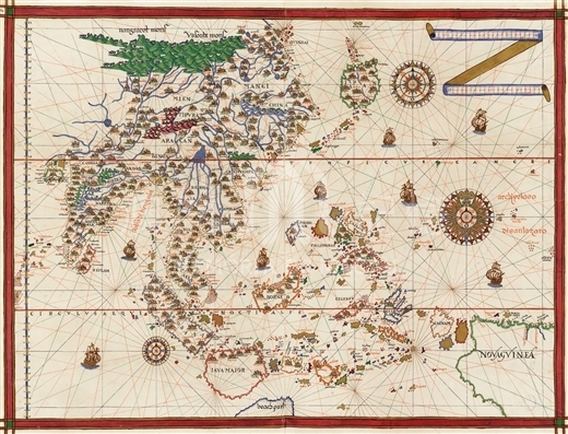
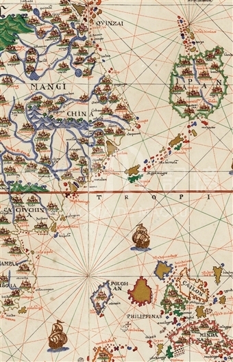
Joan Martines is the royal cartographer of Philip II. He has made many maps with correlation to China. His characteristic is good at assimilating the up-to-date productions of the European cartographers. So the shape of China on Martines's maps is always changing. This map of east and southeastern Asia by Martines in 1587 is made by counterdrawing the map of the same region in Ortelius's Theatrum Orbis Terrarum which was first embodied in the 1570 edition of the atlas. The extension of the map is broad, with India on the west, Malaysian Archipelago and the west half of New Guinea on the southeast. And on the part of East Asia of the map, China and Japan is drawn, when Korea is omitted. There is a visible turn on the eastern coastline of China. The coastline extend northeastward from south of China, until the corner at the area of 30°N, where Liampo is noted. Through the corner, the coastline turns to the northwest. There are regional place names noted as 'Mangi que et Cin et China' on the original map of Ortelius. Martines notes 'Mangi' on the north and 'China' on the south. Martines's map is more colorful and flamboyant with strong style of decoration. The figures of mountains, rivers and islands are colored; the sites of cities are also drawn visualized symbols. The largest river of East Asia on the map is noted as 'cantan R. Gange' on its middle stream. The estuary of the river is as broad as a bay. Cantan is on the northeast shore of the bay. There are many islands of different sizes in and out of the bay. There is a note 'Ilha d: beniaga' outside the islands. To the east of the bay there is another small river flows into the sea. There is a city on the east of its estuary noted as 'ramatan', and it's the miswriting of 'matan' or 'mantan'.
Reference:
[1]. 中村拓. (1967). 鎖国前に南蛮人の作れる日本地図, 第II册. 東京: 東洋文庫, 405-419.
Informações relevantes
Data de atualização: 2020/09/08
Comentários
Comentários (0 participação(ões), 0 comentário(s)): agradecemos que partilhasse os seus materiais e histórias (dentro de 150 palavras).